Call Us
Loading
Loading
We Provide High - Quality BIM Services
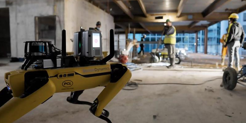
SAFE NIKA employs advanced laser scanning and photogrammetry technologies to capture existing buildings with extraordinary precision, creating comprehensive digital records of physical spaces. By converting reality-captured data into intelligent BIM models, we bridge the gap between as-built conditions and detailed information systems. Our reality capture and scan-to-BIM services enable organizations to document existing infrastructure, support renovation planning, facilitate facility management, and establish accurate baseline conditions for lifecycle data integration.
High-precision laser scanning generates millions of data points that accurately represent building geometry, including complex architectural features, curved surfaces, and mechanical systems. Our point cloud processing workflows automatically classify surfaces, extract building elements, and identify spatial relationships. Advanced algorithms distinguish structural components, MEP systems, and architectural details with remarkable accuracy. The resulting data becomes the foundation for intelligent BIM models that seamlessly integrate reality-captured geometry with semantic information needed for design, analysis, and facility management.
Reality capture and scan-to-BIM services address critical challenges in existing building documentation and renovation planning. Architects and engineers capture precise as-built conditions without relying on outdated drawings or manual measurements. Project teams identify spatial constraints, detect constructability issues, and plan renovations with confidence in accurate base data. Additionally, scan-to-BIM models accelerate facility management operations—providing property teams with comprehensive spatial records that reduce measurement time, support accurate asset inventories, and enable smarter space utilization strategies.
SAFE NIKA specializes in comprehensive scan-to-BIM workflows covering field acquisition, point cloud processing, element extraction, and intelligent model development. Our technical expertise encompasses terrestrial laser scanning, mobile scanning, drone-based photogrammetry, and multi-sensor data fusion. We establish acquisition protocols that optimize accuracy for project requirements, process point clouds to extract building geometry with geometric fidelity, and develop BIM models that capture both spatial precision and semantic meaning. Our workflows maintain full traceability from raw capture data through finished models, ensuring transparency and quality throughout transformation.
Excellence in reality capture and scan-to-BIM requires rigorous quality control, advanced processing techniques, and commitment to geometric and semantic accuracy. SAFE NIKA validates capture completeness, verifies point cloud accuracy against building features, and conducts comprehensive geometric validation of extracted BIM models. Our deliverables include georeferenced models with verified coordinate systems, attribute-rich information systems that link spatial geometry to building metadata, and documentation that supports confidence in downstream applications. This dedication to quality ensures scan-to-BIM models become trusted information foundations for design, renovation, and facility management throughout building lifecycles.

We have worked with many leading companies and completed numerous projects across multiple sectors. We pride ourselves on having a quick turnaround while providing cost-effective solutions.

“This is not the future—it is happening now! SAFE NIKA BIM & Digital Construction pioneers this new era of fully digital project execution by integrating AI, automation, and BIM-based intelligence into every stage of construction.”

Co-founder of SAFE NIKA

“Data drives the modern build! SAFE NIKA leverage the full potential of BIM to unify comprehensive digital data management with precise engineering analysis, ensuring every project phase is backed by intelligent, real-time insights.”

Co-founder of SAFE NIKA


Contact our team quickly. Our representatives will review your request and get back to you as soon as possible.